Why Marine Electronics Literacy Matters
Walking into a boat dealership or browsing listings online, you will encounter helm stations loaded with screens, antennas, and black boxes whose purposes aren't always obvious. Marine electronics have evolved rapidly - what was once reserved for commercial vessels now ships as standard equipment on mid-range recreational boats. Understanding what each system does, and why it matters, is foundational to evaluating any watercraft seriously.
This is especially true because electronics directly affect safety. The US Coast Guard consistently identifies inadequate communication equipment and navigation failure as contributing factors in on-water accidents. Before assessing horsepower or hull design, a knowledgeable shopper should be able to read the electronics suite. For a broader look at how electronics fit alongside hull type, propulsion, and safety systems, see the complete watercraft features guide.
Evaluate Electronics as a System
The most capable individual component adds less value when it cannot communicate with other devices at the helm. When assessing a boat's electronics, check whether the chartplotter, VHF radio, and sonar share a common network bus (typically NMEA 2000 or NMEA 0183). Integrated, networked systems share GPS position data across devices and reduce redundant inputs at the helm.
Core Marine Electronics Explained
Chartplotter
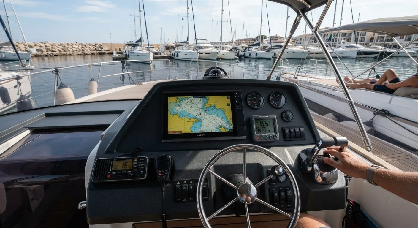
A chartplotter combines a GPS receiver with an electronic navigational chart (ENC) database, displaying the vessel's real-time position overlaid on a digital map of waterways, depth contours, hazards, and aids to navigation. Most modern units support vector charts from providers such as NOAA or commercial chart suppliers, which can be updated as waterways change.
Key specifications to evaluate include screen size, chart coverage area, and update frequency. Some chartplotters integrate sonar transducer inputs, allowing depth data to be displayed on the same screen. For boaters who also navigate by paper, chartplotters serve as a cross-reference rather than a replacement - electronic charts can contain errors, and official printed charts remain a recommended backup.
A chartplotter displays your real-time GPS position over navigational charts, replacing paper chart navigation at the helm.
VHF Marine Radio
The VHF (Very High Frequency) marine radio is the primary communication device on US waterways and is legally required on certain vessel classes under FCC and US Coast Guard regulations. Channel 16 is the international distress and hailing frequency - all vessels with VHF radios are expected to monitor it while underway.
Fixed-mount VHF radios with Digital Selective Calling (DSC) capability can transmit an automated distress signal including the vessel's GPS coordinates when paired with a chartplotter, dramatically accelerating Coast Guard response. Handheld VHF units serve as a backup but typically offer lower transmit power and shorter range. Understanding how to operate a VHF radio - including proper radio protocol - is part of boating fundamentals that every operator should master before leaving the dock.
DSC-enabled VHF radios can transmit an automatic distress signal with GPS coordinates, accelerating emergency response.
Depth Sounder (Fish Finder / Echosounder)
A depth sounder uses sonar - sending acoustic pulses from a hull-mounted or transom-mounted transducer and measuring the time for the echo to return - to calculate and display water depth. This protects the vessel from grounding in shallow or unfamiliar water and is an essential navigation aid when operating outside well-charted channels.
Fishing-oriented models, often called fish finders, render sonar returns as detailed graphical displays showing bottom composition, thermoclines, and fish arches. Technologies such as CHIRP sonar (which sweeps a range of frequencies rather than emitting a single frequency) offer higher resolution returns than traditional single-frequency units. Transducer placement and frequency selection significantly affect performance, particularly in deep water or at higher speeds.
Depth sounders protect the hull from grounding and, in fishing models, reveal bottom composition and fish presence below the vessel.
AIS Transponder
The Automatic Identification System (AIS) is a maritime vessel tracking system that broadcasts a vessel's identity, position, course, and speed via VHF radio frequencies to other AIS-equipped vessels and shore stations. Class B AIS transponders are the standard for recreational vessels in the US and allow the boat to both transmit its own data and receive data from nearby vessels including commercial ships.
AIS is particularly valuable in reduced visibility conditions - fog, rain, or nighttime - where radar alone may not provide sufficient collision avoidance data. Displayed on a chartplotter, incoming AIS targets appear as icons with collision-risk calculations. Understanding how AIS integrates with right-of-way rules reinforces the importance of the maritime navigation rules that govern vessel interactions.
AIS transponders broadcast your vessel's position and identity to nearby ships, significantly reducing collision risk in low-visibility conditions.
Marine Radar
Marine radar emits microwave pulses and detects reflected energy from nearby objects, painting a real-time picture of surrounding vessels, landmasses, and weather formations regardless of visibility conditions. Unlike AIS, radar detects non-transmitting objects - unlit vessels, debris, or shoreline features - making it a complementary rather than redundant technology.
Radar units are rated by transmit power (affecting range) and antenna rotation speed (affecting how quickly the display refreshes). Solid-state radome units have become increasingly common on recreational vessels due to their compact form factor and reduced warm-up time compared to magnetron-based systems. Integration with chartplotters allows radar overlay directly on electronic charts, simplifying interpretation for less experienced operators.
Marine radar detects non-transmitting vessels, debris, and landmasses regardless of visibility - making it a critical complement to AIS.
VHF/DSC-Integrated GPS and EPIRB
An Emergency Position-Indicating Radio Beacon (EPIRB) is a dedicated distress device that, once activated - either manually or automatically upon water immersion - transmits a signal to the international COSPAS-SARSAT satellite system, alerting search and rescue authorities with the vessel's registered identity and GPS position. Unlike VHF radios, EPIRBs operate independently of onboard power and function even if the vessel has sunk.
Category I EPIRBs activate automatically when submerged; Category II require manual activation. All EPIRBs must be registered with NOAA to be operationally useful - an unregistered beacon generates a distress response that cannot be immediately matched to a vessel. For boaters operating in offshore or remote conditions, an EPIRB is widely regarded as a critical last-resort safety layer beyond what onboard radios provide.
A registered Category I EPIRB activates automatically upon water immersion and alerts satellite-linked rescue authorities without any crew action.
Electronics Don't Replace Navigation Skills
GPS and chartplotter failures - whether from power loss, software errors, or signal interference - do occur on the water. The US Coast Guard and boating safety organizations consistently recommend that operators maintain fundamental dead reckoning and paper chart skills as a backup. Electronic systems are tools that augment seamanship, not substitutes for it. See the anatomy of a boat guide for context on how electronics fit within the vessel's overall structure.
Putting It All Together at the Helm
Modern multifunction displays (MFDs) can integrate chartplotter, sonar, radar, and AIS onto a single screen - reducing clutter and allowing the operator to switch between data views quickly. Networked systems also allow instruments like wind sensors or engine monitors to feed into the same display. The integration level that makes sense depends heavily on the boat's intended use: a weekend lake boat has different requirements than an offshore sportfisher.
If you are evaluating a fishing boat in particular, understanding how electronics differ across hull styles is worthwhile - the fishing boats decoded guide covers how center consoles, walkarounds, and bass boats are each optimised for distinct use cases. And if you are still building foundational knowledge about vessel categories overall, the new boater's map to boat categories is a strong starting point.
Finally, electronics only deliver full value when the operator understands what the data means. A chartplotter is far more useful to someone who can also read nautical charts, and situational awareness on the water is sharpened by knowing the maritime navigation rules that govern right-of-way. Electronics inform decisions - they do not replace judgment.